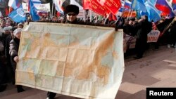
A man holds a map of the Soviet Union during a rally to support Russian-speakers living in Crimea and Ukraine, in the center of the Siberian city of Krasnoyarsk.
Mapmakers Of The World Not United On Crimea
There's a deepening East-West divide over Crimea -- among mapmakers.
As Moscow solidified its hold on Crimea this week, prominent Russian map publishers are rushing to show the Black Sea peninsula as Russian territory.
Russian map publisher Di Em Bi says it started producing new maps on March 19.
The daily "Izvestia" quoted the publisher's owner and director, Sergei Melikov, as saying the new maps will be available in retail stores in about two weeks.
Likewise, the Russian Geographic Society says it will include Crimea as part of Russia in its maps, ITAR-TASS reports.
Meanwhile, two of Russia's biggest Internet companies have also started updating their mapping tools to designate Crimea as part of Russia.
Ksenia Chabanenko of Mail.Ru told ITAR-TASS on March 19 that the company was still "dealing with the technical aspects" of the change. She did not indicate when the new maps would be online.
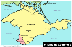
Whose Crimea is it?
Russia's largest search engine, Yandex, also said its mapping service, Yandex.Maps, would be changed to show Crimea as part of Russia "in one of the next updates." It also did not specify a date.
Western map publishers, however, are showing more caution.
The Washington D.C.-based National Geographic Society says it plans to show Crimea as disputed territory.
The society released a statement on March 19 saying that disputed territories "receive special treatment and are shaded gray as 'Areas of Special Status,' with accompanying explanatory text." If Crimea is formally annexed by Russia "it would be shaded gray and its administrative center, Simferopol’, would be designated by a special symbol. When a region is contested, it is our policy to reflect that status in our maps. This does not suggest recognition of the legitimacy of the situation."
The statement came after reports in some U.S. media, including "The Washington Post" and "U.S. News and World Report," claimed that the National Geographic Society would show Crimea as part of Russia as soon as the State Duma ratifies the annexation.
Likewise, Rand McNally, based in Illinois, says it will not be updating the educational atlases and maps displayed in classrooms nationwide. "We wait for the State Department to alert us of any political changes," spokeswoman Amy Krouse, told Bloomberg.
Other American mapmakers continue to show Crimea as part of Ukraine. As of March 20, for example, Google maps was showing Crimea as part of Ukraine.
RFE/RL has been declared an "undesirable organization" by the Russian government.
If you are in Russia or the Russia-controlled parts of Ukraine and hold a Russian passport or are a stateless person residing permanently in Russia or the Russia-controlled parts of Ukraine, please note that you could face fines or imprisonment for sharing, liking, commenting on, or saving our content, or for contacting us.